HWR
Historical Landmark
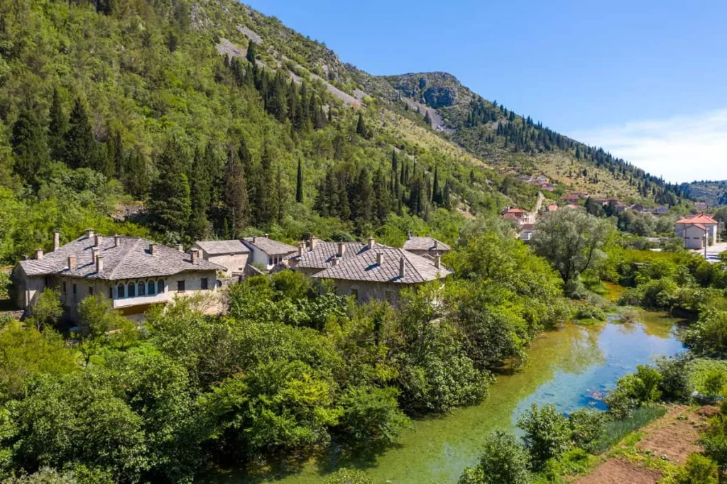
Residential complex Begovina
Begovina, a residential complex in Stolac, was built as an economic entity with inns and gardens, separate from the rest of the city. It shows respect for natural terrain and privacy, forming a protected family territory. Architecturally, it consists of four parts: the public access road, the entrance yard with four buildings, a semi-private courtyard, and a private family house. The complex is surrounded by a high stone wall on three sides, with the Bregava River acting as a natural border on the fourth side. The complex comprises five inn buildings, six residential buildings, and auxiliary structures. Access is from the south side via Ćuprija in Begovina, a stone bridge that connected the Rizvanbegović family houses. The complex is considered one of the most beautiful and significant residential complexes in Bosnia and Herzegovina.
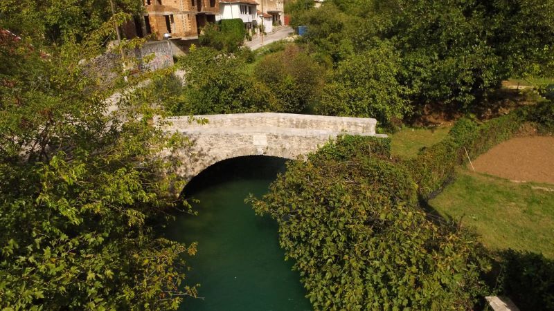
Sara’s Bridge
After the Congress of Berlin in 1878, Bosnia and Herzegovina became part of Austria-Hungary, leading to significant changes in the local social structure. During this period, the Bridge of Sara Kašiković, also known as the Girls’ Bridge, was built in 1896 on the right shore of the river Bregava. The bridge was constructed for private use, connecting a road and gardens on the other side of the river. Its owner, Sara Kašiković, built it as a tribute to her lost love, Salko, whom she could not marry due to religious differences. Sara later built a hotel named Europe on the site where they used to meet.
Šarić House – Branko Šotra Gallery
The Šarić House, also known as Branko Šotra Gallery, is situated near Čaršija, the main crossroads of trade and travel in Stolac. Built in 1734/1735, the Šarić family, a prominent Muslim family in the region, was associated with this historical building. Ismail-kapetan, a notable member of the family, contributed significantly to the town’s development by constructing a mosque, school, cistern, and shops. In 1963, the Art Gallery in Sarajevo established its first external branch in Stolac and named it after Branko Šotra, a renowned print artist from the former Yugoslavia, who was born in Stolac. The gallery housed 92 prints donated by Šotra, forming a permanent exhibition. His artwork featured striking black and white contrasts, portraying World War II events in his early works and later shifting focus to Herzegovinian landscapes and people.
St. Peter and Paul Church
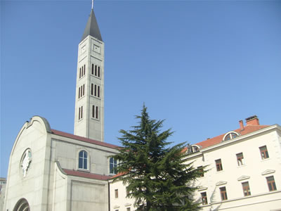
In 1866, the Ottomans played a significant role in the construction of the Catholic church and Franciscan Monastery in Mostar. The Complex takes great pride in its expansive library, housing over 50,000 ancient volumes from both Western and Eastern authors, making it the largest library in Herzegovina. Additionally, the building showcases an important art collection featuring works by Italian Masters from the 16th and 17th centuries. This historical site stands as a testament to the rich cultural exchange and legacy of diverse civilizations coming together in harmony.
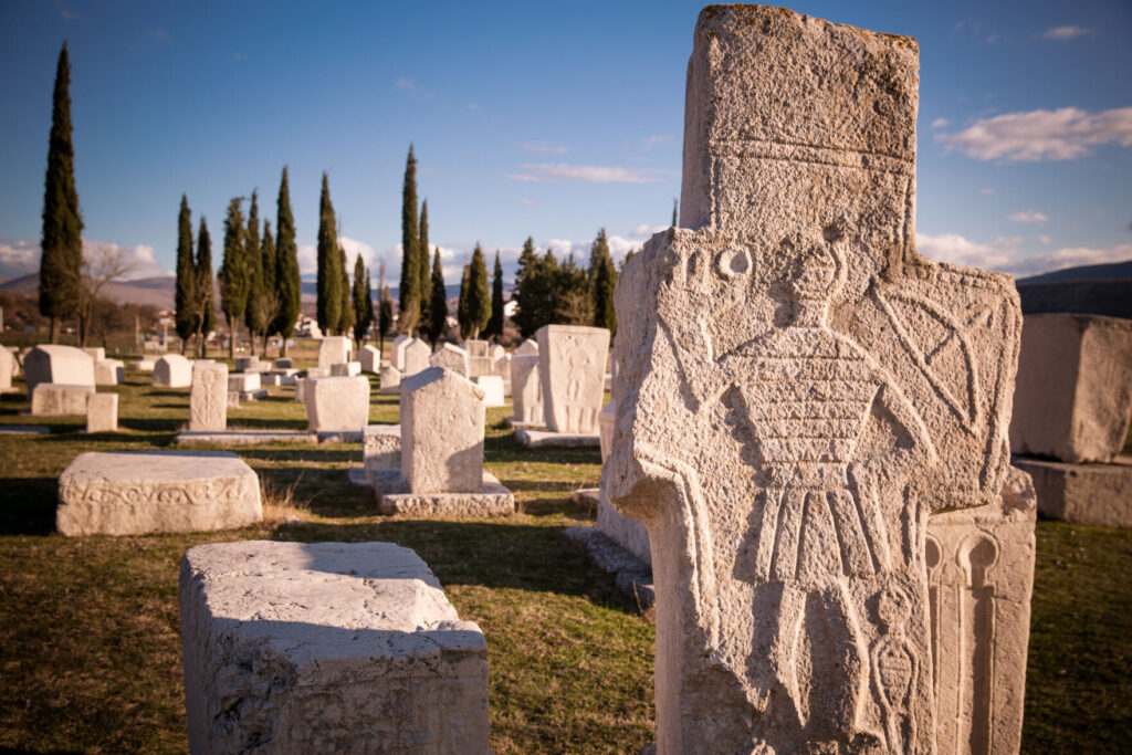
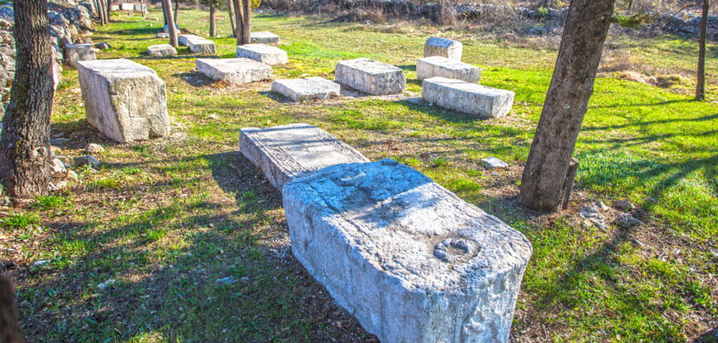
Stećak tombstones – Boljuni i Radimlja
The Necropolis of Stećak Boljuni is located in Boljuni, 12 kilometers southwest of Stolac. 269 stećaks have been preserved in the necropolis, in two groups. According to the forms, the most are chests – 176, then slabs – 76, then gables – 12 and 3 crosses. Out of the total number, 92 stećaks (34%) are decorated. And while the Radimlja necropolis stands out for its wealth, variety and high quality of relief motifs, the Boljuni necropolis stands out for its large number of inscriptions – 19 (7%), which is the first in terms of the number of inscriptions place in Bosnia and Herzegovina. The most common ornament on Boljuna stećci is a cross, followed by a bent vine with a trefoil (the motif is characteristic of the whole of Herzegovina, and it appears quite often here), a shield with a sword, as well as rosettes, then various borders, a crescent moon, scenes of hunting, tournaments, carts etc
Stećak tombstones in Ljubuški
In the vicinity of Ljubuški 214 tombstones were registered in 7 necropolises, of which: 88 tombstone slats, 78 grave chests, 9 sarcophagi and 48 grave slabs and grave chests. Of the 176 tombstones described, half are slabs, half are chests, while the sarcophagus is relatively small, but they are artistically better decorated than the others. Out of 176 specimens, 81 are decorated, 33 of them with the symbol of the cross, which was especially evident in the upper part of the village Studenci. Decorative motifs on the necropolises with stećak tombstones of the Ljubuški region are as follows: shield motif with sword, oyster symbol, human figures with decoration, twisted rope and ribbons, crescent, rosettes, trefoil tendrils, wheel, spiral motif, hunting scenes, falcon symbol and tournament. Several stonemason workshops were active in this area as bearers of various influences. It is not the same workshop of masters who made monuments at the necropolis in the upper part of the village Studenci and those who worked at the necropolis “Gračine” in Bijača, Zvirići and Pržine. Most of the monuments belong to the XIV. and XV. century, some specimens, however, could have appeared much earlier, perhaps even in the XII. century.
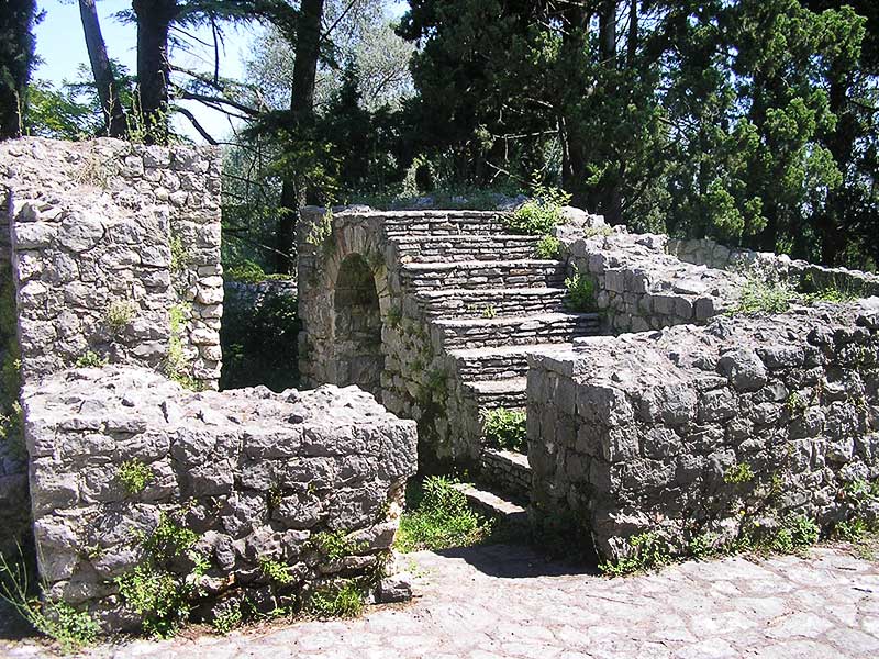
Antique Villa Mogorjelo
Mogorjelo is one of the most important monuments of the Roman era in Bosnia and Herzegovina and belongs to the most beautiful buildings of late antique architecture. Mogorjelo supplied the Roman city of Narona and probably served in the defense of the city and its surrounding, a dense grove of coastal trees (cypress) gives this monument a particularly beautiful frame. The building was excavated between 1889 and 1903, and in the following years it was conserved, being declared as a national monument in 2002.
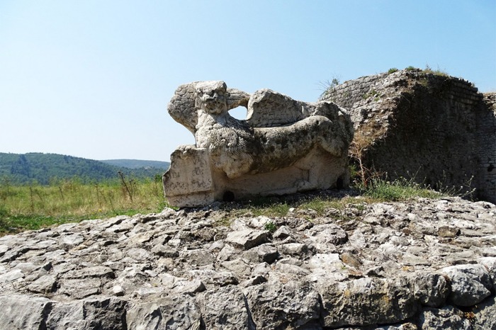
Archaeological site Gabela
Gabela is a national cultural monument of Bosnia and Herzegovina. Due to its strategic location, Gabela was also inhabited in Roman times, from which we have the remains of a brick factory and farm buildings on the outskirts of the town. Of the large number of medieval buildings, the remains of the old fort and a stone plaque with a large winged lion, the symbol of the Republic of Venice, are the most impressive to this day. Gabela was from the 15th to the 18th century a large trading center, but also an important strategic fortress on the Venetian-Turkish border. At one time it was known as the slave square. Various political and economic interests were competing for supremacy over Gabel. The Turks occupied it in 1477, and after several failed attempts in 1694, the Venetians occupied Gabela, then with the Peace of Požarevac in 1718, Gabela belonged to the Turks, and the Venetians demolished all the important buildings. Gabela is again under Turkish administration, but without its former power. During the Austro-Hungarian rule and the construction of the narrow-gauge railway, Gabela was a junction from Sarajevo to Dubrovnik and Metković. The Mexican scientist Roberto Salinas Price developed a hypothesis based on geographical information in the Iliad that the Trojan War was in the valley of the Neretva River, that is, that Gabela was Ilios, the capital of the state of Troy.
Antique Villa Mogorjelo
Mogorjelo is one of the most important monuments of the Roman era in Bosnia and Herzegovina and belongs to the most beautiful buildings of late antique architecture. Mogorjelo supplied the Roman city of Narona and probably served in the defense of the city and its surrounding, a dense grove of coastal trees (cypress) gives this monument a particularly beautiful frame. The building was excavated between 1889 and 1903, and in the following years it was conserved, being declared as a national monument in 2002.
Archaeological site Gabela
Gabela is a national cultural monument of Bosnia and Herzegovina. Due to its strategic location, Gabela was also inhabited in Roman times, from which we have the remains of a brick factory and farm buildings on the outskirts of the town. Of the large number of medieval buildings, the remains of the old fort and a stone plaque with a large winged lion, the symbol of the Republic of Venice, are the most impressive to this day. Gabela was from the 15th to the 18th century a large trading center, but also an important strategic fortress on the Venetian-Turkish border. At one time it was known as the slave square. Various political and economic interests were competing for supremacy over Gabel. The Turks occupied it in 1477, and after several failed attempts in 1694, the Venetians occupied Gabela, then with the Peace of Požarevac in 1718, Gabela belonged to the Turks, and the Venetians demolished all the important buildings. Gabela is again under Turkish administration, but without its former power. During the Austro-Hungarian rule and the construction of the narrow-gauge railway, Gabela was a junction from Sarajevo to Dubrovnik and Metković. The Mexican scientist Roberto Salinas Price developed a hypothesis based on geographical information in the Iliad that the Trojan War was in the valley of the Neretva River, that is, that Gabela was Ilios, the capital of the state of Troy.
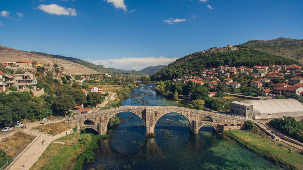
Arslanagić Bridge
Water is one of the most important natural resources of east Herzegovina. Trebišnjica possesses a vast unused potential, and it used to be the longest sinking river in Europe (98km). It is precisely in Trebinje where its beauty takes a full form. Banks of Trebišnjica are intertwined with many bridges, one of those standing out with exceptional beauty is the Arslanagić bridge, most famous monument from the Ottoman period in Trebinje. The Bridge played a very important role in Balkan architecture of 16th century. Mehmed-Pasha Sokolović built the bridge 1574 in honor to his son who was killed in the battle with Venice. When Turks got pushed away from Herceg Novi in 1687, many Turkish families moved from this town to Trebinje. A certain individual named Arslan-aga was among them. He was given land east of Trebinje: Zupci, Necvijeće and Jasen, and was also put in charge of collecting fee people had to pay to cross this bridge. Since that, this bridge was named after him – Arslanagić (Arslan-aga) bridge. With the construction of hydropower system on Trebišnjica in 1965 the bridge got submerged under the newly created reservoir lake. However, in 1966 the Institute for Protection of Cultural Monuments requested the bridge to be moved upstream to the new location – between Gradina (right river bank) and Police (left).